
Welcome to the Marietta College Department of Biology and
Environmental Science's Biomes of the World
web site! ![]()
Although designed primarily for our students in Environmental Biology (Biology 102) and Ecology (Biology 318), we are placing it on the web for the benefit of students and interested people everywhere. The photography on this site has been done by Marietta College faculty, staff, students and friends. The photographs may be used for any educational purpose by any non-profit educational institution, but please email for permission. More about Photo Permissions. More about the project.
Biomes of the World - Click on the map to visit a biome or habitat.
Scroll down for more information on biomes!
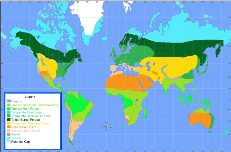
Click here for a full-size version of the biome map.
Biomes are major types of ecological communities. These communities are recognizable on a regional scale, although many other communities may exist there as well. For instance, here in eastern North America where Marietta College is located, our biome is the temperate deciduous forest. At La Selva, in Costa Rica, the biome is the tropical rain forest.
Biomes are formed as a result of the climate present at a site (more on this in a minute). Perhaps you are familiar with the concept of succession, whereby a series of biological communities replace each other over time in a predictable fashion. For instance, in southern Ohio, an abandoned farm field will first be covered with a community of weeds and grasses; organisms whose seeds are small and which can colonize the disturbed habitat quickly. Plants like milkweed, goldenrod, smartweed and joe-pye weed also come early to an abandoned field. Over time, certain shrubs and small tree species (sassafras, hawthorn, aspen, locust, etc.) will begin to take over from the grasses. Following these small trees are the larger ones such as oaks, hickories (and, some time ago, chestnuts). If the site is undisturbed for a very long time - hundreds of years - it may be completely taken over by beech trees. This sequence will occur over and over again in southern Ohio as long as the climate does not change. The end result of succession in southern Ohio is always a temperate deciduous forest, where trees lose their leaves in the cold winters. Down in Costa Rica at La Selva, succession is different, with different plant species making up the communities, and there the end result is a tropical rain forest. In western Costa Rica, the final result of succession is a tropical seasonal forest. In terms of succession, these final communities that develop at a site are called climax communities, and these climax communities form the basis for the biome classification.
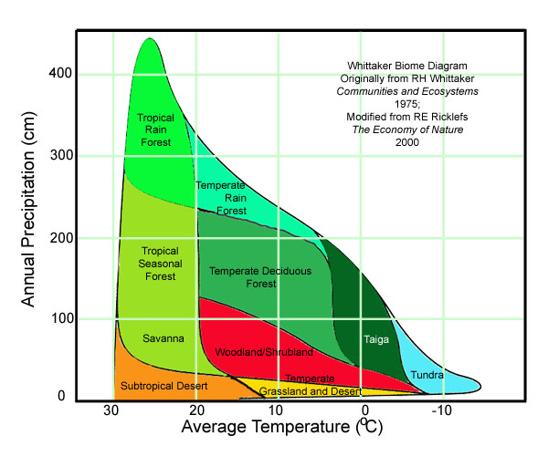
As mentioned, climate plays an important role in the development of biomes. Robert Whittaker, an American ecologist, plotted rainfall vs. temperature for points all over the globe on a single graph (see below). He then looked at what biomes had developed at those sites, and was able to group the different biomes according to mean annual temperature and precipitation, as the shaded areas in the graph below indicate. There are several variations on these diagrams, one of them is:
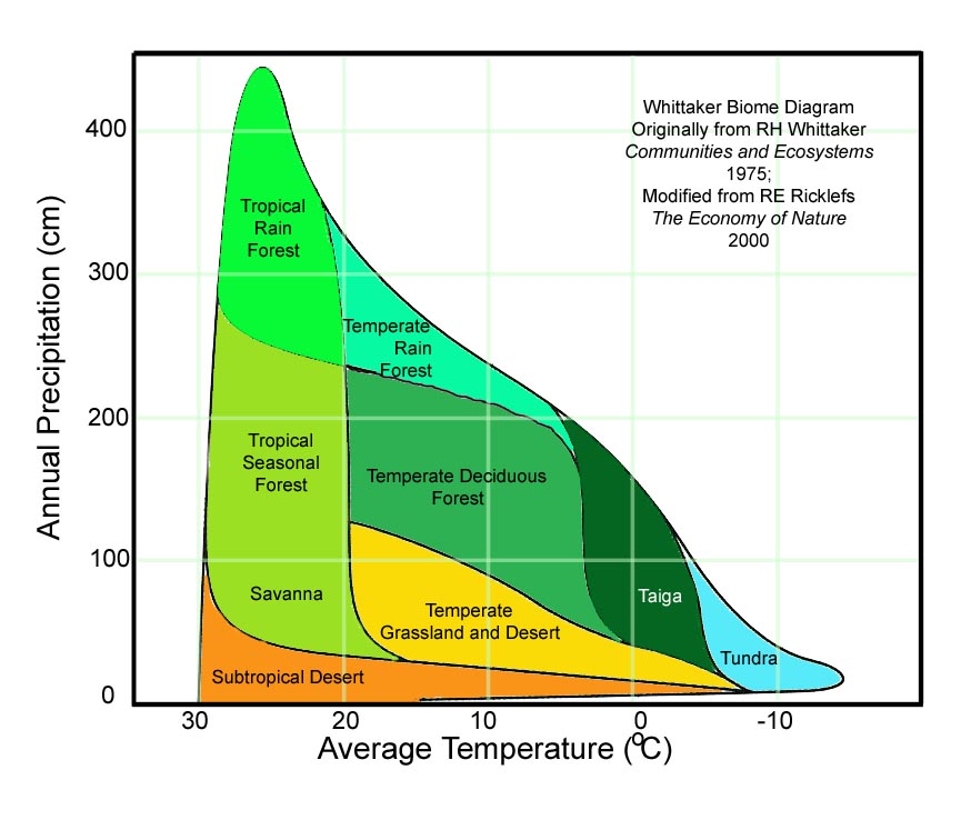
Note that in Whittaker's diagram the temperature axis is reversed; that is temperature goes DOWN as you move to the right. Theoretically, if you know the average temperature and precipitation for a site, you should be able to predict what biome will develop there. Try your hand - look at the values in the table below, compare them to the diagram above, and predict the biome. To "reveal" the biome, highlight the appropriate box in the biome column.
| Place | Average Temperature oC | Annual Precipitation (cm) | Biome |
| La Selva, Costa Rica | 22.1 | 403 | Tropical Rain Forest |
| Marietta, Ohio | 12 | 105 | Temperate Deciduous Forest |
| Pasadena California | 18.2 | 51.8 | Savanna |
| Ferron, Utah | 8.8 | 20.9 | Desert |
| Tucson, Arizona | 21.1 | 21.9 | Subtropical Desert |
| Santa Rosa, Costa Rica | 26 | 165 | Tropical Seasonal Forest |
| Brazzaville, Congo | 25 | 137 | Tropical Seasonal Forest |
| Lambarene, Gabon | 25.7 | 195 | Tropical Seasonal Forest |
| Amauulu, Hawaii | 20 | 410 | Tropical Rain Forest |
| Toolik Lake, Alaska | -8.8 | 18 | Tundra |
| Beijing, China | 11.8 | 63.5 | Temperate Grassland |
| Seoul, South Korea | 11.2 | 137 | Temperate Deciduous Forest |
| Archbold Biological Station | 29.1 | 131 | Tropical Seasonal Forest* |
| Everglades National Park (Flamingo) | 28.1 | 159 | Tropical Seasonal Forest* |
The last two are marked with an asterisk to
point out an important concept. The biomes are very general in nature;
there are many other habitat types that develop in certain locations regardless
of the rainfall and temperature. For instance, the habitat type at the
Archbold Station in Florida is the unique Florida Scrub, not a tropical seasonal
forest. Look at the map of Ohio, below: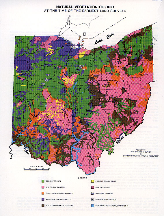
First, recognize that the term "temperate deciduous forest" can be further subdivided depending on exactly what type of trees make up that forest. You could have a mixed oak forest, or an oak-sugar maple forest, or a beech forest, just to name a few. Most of the forest types found in Ohio when it was first settled by Europeans could be considered to be temperate deciduous forests, but notice that there were also prairies, swamps, oak savannas, bogs and the like in the state. Some of these habitats are dependent on the nature of the land; a particular type of bedrock or drainage pattern my change a site so that a different type of community can live there. Therefore, while climate controls the overall biome, it is not the only factor, and even within an overall biome "type" there are a number of different community types possible. The wide swaths on the biome maps above are a bit more complex the closer one gets to the ground.
 Likewise,
even at the biome level there are disagreements as to where to draw the
boundaries, and taking a closer look often leads to a different
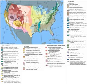
conclusion. The map of the US inset here shows the biome boundaries
somewhat differently than the map above does. You can click on the map to
bring up a full screen version.
Likewise,
even at the biome level there are disagreements as to where to draw the
boundaries, and taking a closer look often leads to a different
conclusion. The map of the US inset here shows the biome boundaries
somewhat differently than the map above does. You can click on the map to
bring up a full screen version.
You should also be aware that all Whittaker diagrams are not alike; there are several schemes for dividing up the biomes and these typically modify the Whittaker diagram to some extent. For example, a modification from a more recent textbook looks like the picture below left. In the Whitaker diagram already introduced above (and reproduced again below right), the subtropical desert extends all the way down to temperatures below zero - not very likely given the name. The woodland/shrubland biome is deleted completely. The figure to the left (below) includes the woodland shrubland by placing it in the area ascribed to temperate grassland and desert and moving the temperate grassland and desert down to part of the area ascribed to subtropical desert. I agree with calling the "cold" deserts something other than subtropical, but grasslands are found in areas with considerably more rainfall than the diagram to the left would indicate. The truth is that biome assignments in this area are complex, and probably due to more than simple rainfall and average annual temperature. For instance, the timing of the rainfall is critical; the presence or absence of fire in the biome is also critical; neither appear on the graph. The role of fire, for instance, is key in some situations; some scientists believe that the prairie of the American West may largely be due to fires set by pre-historic humans over the last 10,000 years or so - and not due to the climate, which in some parts of the prairies is wet enough to support trees (but the trees are killed by the human-set-fires). Thus, what appears to be "natural" isn't, at least by a definition of natural that excludes any human activity. Also, recognize that because of daily fluctuations between high daytime and very low nighttime temperatures, the average temperature for a desert isn't really very descriptive of the temperature regime for that area. The reader is perhaps best served by remembering that these diagrams are simple by their very nature and that the boundaries may not be as precise as what the lines seem to indicate.
"Modified" Whittaker diagram showing the woodland/shrubland biome and displacement of the temperate grassland/desert biome into a portion of the former subtropical desert biome. |
"Original" Whittaker diagram for these web pages.
|
Finally, one more concept needs to be remembered. The climate that develops in an area is due in part to its location with regard to the equator - i.e. the closer you are to the equator the warmer the biome is likely to be, but there are other factors as well. An area far from the ocean will be drier (in general) than areas adjacent to the ocean. Likewise, mountains affect climate. As you go up a mountain, air cools, about 10° C for every 1,000 meters; this is known as adiabatic cooling (conversely, descending air warms). Therefore, all things being equal, mountain tops at a given latitude will be cooler than land at sea level. Also, that cooling air can hold less water; as the air cools clouds form and precipitation follows. A tall mountain range may "wring out" most of the water as the air passes over the mountains; the descending air on the far side of the mountain is very dry and actually pulls moisture from the ground and can create a "rain shadow" - one form of desert. This diagram shows how the process works in Costa Rica; there the moist Caribbean air cools as it moves towards the Pacific and causes lots of rain to fall on the eastern side of the country; on the western side it is much drier.

A similar situation occurs in the desert southwest of the US; here the air moves from west to east and the rain falls on the western slopes of the Sierra Nevada and dry conditions predominate on the eastern slopes in Nevada.
![]()
The Ecology Pages (link below) explain a lot of ecological phenomena such as succession, predation, symbioses, etc. The Index page has direct links to many of the subjects covered on this website.
![]()